
文件:Panama-Canal-rough-diagram-quick.jpg
Panama-Canal-rough-diagram-quick.jpg (560 × 540 chiông-só, ùng-giông duâi-nâung: 57 KB,MIME lôi-hìng: image/jpeg)
總結
| Mièu-sŭk |
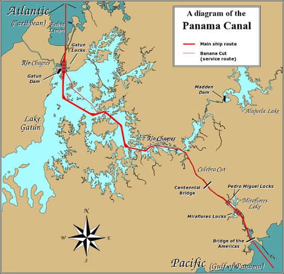
English: A diagram illustrating the layout of the Panama Canal (in quick JPEG format, auto-resizes to fit).
Due to the shape of the Isthmus of Panama, the Pacific end of the canal is actually the south-east end, and the Caribbean / Atlantic end is at the north-west. From the Pacific side, the Miraflores and Pedro Miguel locks (with two and one stages respectively) lead up to the highest level of the canal, 26 metres (85 feet) above sea level. The Culebra Cut (or Gaillard Cut) leads to Gatún Lake, created by damming the Chagres River; then the Gatún Locks lead back down to sea level in Limón Bay. The heavy red line shows the ship route. The narrower red line in Gatún Lake is the Banana Cut, a shortcut used by canal boats and yachts. |
| Nĭk-gĭ | |
| Lài-nguòng | Source URL: Image:Panama_Canal_Rough_Diagram.png (GFDL file, reduced/retouched, saved JPEG format (5x faster than PNG), intended for use in frequently-read Wiki articles). |
| Cáuk-ciā | User:Johantheghost (JPEG version by Wikid77) |

|
本圖片是以PNG、GIF或JPEG格式上傳。然而,其中包含的資料或訊息,應該重新建立成可縮放向量圖形(SVG)檔案,以更有效率或更準確的方式儲存。如有可能,請上傳本圖片的SVG格式版本。在上傳之後,請修改維基各姊妹計畫中所有使用舊版圖片的條目(列在圖像連結章節中),替換為新版圖片,並在舊圖片的描述頁中加入{{Vector version available|新圖片名稱.svg}}模板,同時移除本模板。
|


版權說明

|
已授權您依據自由軟體基金會發行的無固定段落、封面文字和封底文字GNU自由文件授權條款1.2版或任意後續版本,對本檔進行複製、傳播和/或修改。該協議的副本列在GNU自由文件授權條款中。 |
| 此檔案採用創用CC 姓名標示-相同方式分享 3.0 未在地化版本授權條款。 | ||
| ||
| 已新增授權條款標題至此檔案,作為GFDL授權更新的一部份。 |
Ùng-giông lĭk-sṳ̄
Sōng-dĕk siŏh bĭk nĭk-gĭ/sì-găng lì káng hiā sèng-hâiu gì ùng-giông.
| Nĭk-gĭ/Sì-găng | Sáuk-liŏk-dù | Chióh-cháung | Ê̤ṳng-hô | Suók-mìng | |
|---|---|---|---|---|---|
| hiêng-káik-sì | 2006 nièng 12 nguŏk 26 hô̤ (B2) 17:28 | | 560 × 540(57 KB) | Wikid77 | == Summary == A diagram illustrating the layout of the Panama Canal (in quick JPEG format, auto-resizes to fit). Due to the shape of the Isthmus of Panama, the Pacific |
Lièng-giék
Â-dā̤ gì hiĕk-miêng lièng gáu ciā ùng-giông:
Cuòng-mĭk ùng-giông sāi-ê̤ṳng cìng-huóng
Â-dā̤ gì gì-tă wiki găk lā̤ sāi cī-bĭh ùng-giông:
- ar.wikipedia.org gì sāi-ê̤ṳng cìng-huóng
- cs.wikipedia.org gì sāi-ê̤ṳng cìng-huóng
- de.wikipedia.org gì sāi-ê̤ṳng cìng-huóng
- en.wikipedia.org gì sāi-ê̤ṳng cìng-huóng
- es.wikipedia.org gì sāi-ê̤ṳng cìng-huóng
- fi.wikipedia.org gì sāi-ê̤ṳng cìng-huóng
- fr.wikipedia.org gì sāi-ê̤ṳng cìng-huóng
- gor.wikipedia.org gì sāi-ê̤ṳng cìng-huóng
- hu.wikipedia.org gì sāi-ê̤ṳng cìng-huóng
- id.wikipedia.org gì sāi-ê̤ṳng cìng-huóng
- jv.wikipedia.org gì sāi-ê̤ṳng cìng-huóng
- km.wikipedia.org gì sāi-ê̤ṳng cìng-huóng
- li.wikipedia.org gì sāi-ê̤ṳng cìng-huóng
- map-bms.wikipedia.org gì sāi-ê̤ṳng cìng-huóng
- min.wikipedia.org gì sāi-ê̤ṳng cìng-huóng
- mn.wikipedia.org gì sāi-ê̤ṳng cìng-huóng
- simple.wikipedia.org gì sāi-ê̤ṳng cìng-huóng
- th.wikipedia.org gì sāi-ê̤ṳng cìng-huóng
- ur.wikipedia.org gì sāi-ê̤ṳng cìng-huóng
- vi.wikipedia.org gì sāi-ê̤ṳng cìng-huóng
- www.wikidata.org gì sāi-ê̤ṳng cìng-huóng
- zh.wikinews.org gì sāi-ê̤ṳng cìng-huóng