
文件:20090524 Buildings along Chicago River line the south border of the Near North Side and Streeterville and the north border of Chicago Loop, Lakeshore East and Illinois Center.jpg

Ê̤ṳ-lāng chék-cháung:800 × 287 chiông-só. Gì-tă hŭng-biêng-lŭk: 320 × 115 chiông-só | 640 × 230 chiông-só | 1,024 × 367 chiông-só | 1,280 × 459 chiông-só | 2,560 × 918 chiông-só | 8,600 × 3,084 chiông-só.
Nguòng-dā̤ gì ùng-giông (8,600 × 3,084 chiông-só, ùng-giông duâi-nâung: 9.28 MB,MIME lôi-hìng: image/jpeg)
總結
| Mièu-sŭk |
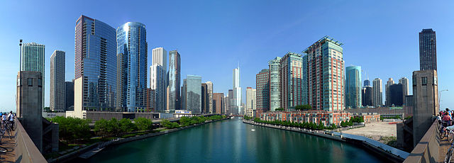
English: The Chicago River is the south border of the Near North Side and Streeterville and the north border of the New Eastside (viewed from Lake Shore Drive with Trump International Hotel and Tower at the jog in the river at the center. This 6-part composite panorama shows the optical center of the main branch of the Chicago River looking west (upstream) as seen from the upper vehicle deck of the Lake Shore Drive Bridge. The Trump Tower is at center (SOM), with Mies van der Rohe's 330 North Wabash slightly to the left of center. On the right bank is Streeterville, and the northern Loop is on the left. From left to right: The Parkshore, North Harbor Tower (both set back), The Chandler, The Regatta, The Tides, Aon Center (background), Aqua, Swissotel Chicago, Columbus Plaza, Hyatt Regency Chicago (west tower), One Illinois Center, Marina City, 330 North Wabash, Trump International Hotel & Tower Chicago, Sheraton Chicago Hotel & Towers, Cityfront Place, River View (west & east towers), Parkshore East, McClurg Court Center, John Hancock Center, 400 East Ohio, the Chicago Spire site, 401 East Ontario, Lake Shore Plaza, Onterie Center, North Pier Apartments |
| Nĭk-gĭ | |
| Lài-nguòng | https://www.flickr.com/photos/mindfrieze/3624597377/ |
| Cáuk-ciā | flickr user mindfrieze |
| 其他版本 |


|
版權說明
此檔案採用創用CC 姓名標示-相同方式分享 2.0 通用版授權條款。
- Nṳ̄ â̤-sāi cê̤ṳ-iù:
- hŭng-hiōng – Hók-cié, huák-buó, diòng-bó̤ buōng cáuk-pīng
- tṳ̀ng-sĭng siŭ-gāi – gāi-biĕng cáuk-pīng
- Nâ diŏh áng ī-hâ gì dèu-giông:
- biĕu-sê miàng-sáng – 您必須指名出正確的製作者,和提供授權條款的連結,以及表示是否有對內容上做出變更。您可以用任何合理的方式來行動,但不得以任何方式表明授權條款是對您許可或是由您所使用。
- dùng-iông huŏng-sék hŭng-hiōng – Lí nā kái-tōng, piàn-khoán, he̍k-chiá kun-kù pún chok chhòng-chō, lí kaⁿ-taⁿ ē-tàng ēng kap pún chok kâng-khoán he̍k-chiá saⁿ-chhiūⁿ ê hí-khó lâi hoat-pò͘ chò--chhut-lâi ê chok-phín.
| This image, originally posted to Flickr, was reviewed on 8 August 2009 by the administrator or reviewer Leoboudv, who confirmed that it was available on Flickr under the stated license on that date. |
Ùng-giông lĭk-sṳ̄
Sōng-dĕk siŏh bĭk nĭk-gĭ/sì-găng lì káng hiā sèng-hâiu gì ùng-giông.
| Nĭk-gĭ/Sì-găng | Sáuk-liŏk-dù | Chióh-cháung | Ê̤ṳng-hô | Suók-mìng | |
|---|---|---|---|---|---|
| hiêng-káik-sì | 2010 nièng 9 nguŏk 4 hô̤ (B6) 02:10 | 8,600 × 3,084(9.28 MB) | Mindfrieze | As the original author of this photo, I have recomposited this version from the original six photos to correct a slight tilt in the original composite. I also adjusted color levels and saturation slightly. Hugin 2009.4.0 and Gimp 2.6.8 were used. | |
| 2009 nièng 8 nguŏk 8 hô̤ (B6) 13:20 | 8,613 × 3,301(13.08 MB) | TonyTheTiger | {{Information |Description={{en|1=en:Chicago River is the south border of the Near North Side and en:Streeterville and the north border of en:Chicago Loop, en:Lakeshore East and en:Illinois Center |
Lièng-giék
Mò̤ hiĕk-miêng lièng gáu ciā ùng-giông.
Cuòng-mĭk ùng-giông sāi-ê̤ṳng cìng-huóng
Â-dā̤ gì gì-tă wiki găk lā̤ sāi cī-bĭh ùng-giông:
- ast.wikipedia.org gì sāi-ê̤ṳng cìng-huóng
- cy.wikipedia.org gì sāi-ê̤ṳng cìng-huóng
- en.wikipedia.org gì sāi-ê̤ṳng cìng-huóng
- Chicago River
- Chicago Loop
- Talk:Chicago River
- Lake Shore Drive
- Streeterville
- Near North Side, Chicago
- Illinois Center
- Lakeshore East
- Wikipedia:WikiProject Chicago
- Wikipedia:Featured pictures/Places/Panorama
- Wikipedia:WikiProject Chicago/Featured articles
- Portal:United States/Selected panorama
- Wikipedia:Featured pictures thumbs/25
- Wikipedia:Featured picture candidates/Buildings along Chicago River
- Wikipedia:Featured picture candidates/September-2010
- Wikipedia:Wikipedia Signpost/2010-09-20/Features and admins
- User talk:TonyTheTiger/Archive 50
- Portal:United States/Selected panorama/32
- User:JeremyA/sandbox/Chicago River
- Template:POTD/2012-07-12
- Wikipedia:Picture of the day/July 2012
- User talk:TonyTheTiger/Archive 71
- Wikipedia:Main Page history/2012 July 12
- User:StarChaser Tyger/sandbox
- User:JeremyA/Sandbox/Chicago
- Wikipedia:Wikipedia Signpost/Single/2010-09-20
- Portal:Rivers/Selected panorama
- Portal:Rivers/Selected panorama/8
- User talk:Mindfrieze/Archive 1
- en.wikibooks.org gì sāi-ê̤ṳng cìng-huóng
- en.wikinews.org gì sāi-ê̤ṳng cìng-huóng
- es.wikipedia.org gì sāi-ê̤ṳng cìng-huóng
- ext.wikipedia.org gì sāi-ê̤ṳng cìng-huóng
- fa.wikipedia.org gì sāi-ê̤ṳng cìng-huóng
- منار شیکاگو
- کاربر:Kasir/نگارههای برگزیده من
- ویکیپدیا:نگارههای برگزیده/جاها/سراسرنما
- ویکیپدیا:نگاره روز/آوریل ۲۰۱۴
- ویکیپدیا:گزیدن نگاره برگزیده/دسامبر-۲۰۱۳
- بحث کاربر:Kasir/بایگانی ۱۶
- رود شیکاگو
- ویکیپدیا:گزیدن نگاره برگزیده/20090524 Buildings along Chicago River line the south border of the Near North Side and Streeterville and the north border of Chicago Loop, Lakeshore East and Illinois Center.jpg
- الگو:نر/2014-04-16
- الگو:نر محافظت شده/2014-04-16
- fr.wikipedia.org gì sāi-ê̤ṳng cìng-huóng
檢視此檔案的更多全域使用狀況。