
文件:Ganges Delta ESA22274217.jpeg

Ê̤ṳ-lāng chék-cháung:519 × 600 chiông-só. Gì-tă hŭng-biêng-lŭk: 208 × 240 chiông-só | 415 × 480 chiông-só | 664 × 768 chiông-só | 886 × 1,024 chiông-só | 1,772 × 2,048 chiông-só | 3,423 × 3,957 chiông-só.
Nguòng-dā̤ gì ùng-giông (3,423 × 3,957 chiông-só, ùng-giông duâi-nâung: 6.2 MB,MIME lôi-hìng: image/jpeg)
總結
| Mièu-sŭk |
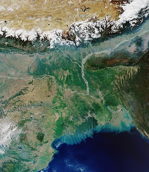
English: The Copernicus Sentinel-3 mission takes us over the Ganges Delta – the world’s largest river delta. Covering an area of around 100 000 sq km, the Ganges Delta lies in both Bangladesh and the State of West Bengal in India. The delta is formed mainly by the large, sediment-laden waters of the Ganges and Brahmaputra rivers. The river bed of the Ganges can be seen in the left of the image, while Brahmaputra can be seen to the right. The snow-covered Himalayas can be seen at the top of the image. The Ganges river carries fertile soil and nutrients, which it deposits across its vast delta floodplain. The river flows for over 2400 km from the Himalayas before emptying into the Bay of Bengal – the world’s largest bay. It is here where the murky coloured waters mix with the darker coloured waters of the Indian Ocean. The delta is largely covered with a swamp forest, known as the Sundarbans, and can be seen in dark green near the coast with several rivers snaking through it. The Sundarbans, which translates as 'beautiful forest' in Bengali, are the world’s largest mangrove forest and provide a critical habitat for numerous species, including the Bengal tiger and the Indian python. The city of Kolkata (formerly Calcutta) is visible near the Sundarbans in the lower-centre of the image. With over 14 million inhabitants, Kolkata is one of India’s largest cities and is the dominant urban centre of eastern India. Dhaka, the capital of Bangladesh, can be seen in the lower-right of the image, just north of the Buriganga river. Dhaka is Bangladesh’s most populous city and is one of the largest metropolises in South Asia. With a population of over 100 million people, the delta is one of the most densely populated deltas in the world and is extremely vulnerable to climate change. The residents of this region are particularly at risk from repeated catastrophic floods due to heavy runoff of meltwater from the Himalayas, intense rainfall during the monsoon season and from accelerated sea-level rise exacerbated by land subsidence. Sea-level rise is a global issue, but regional differences in sea-level rise put some places at risk more than others. In the coming decades, Asia is likely to feel the worst effects because of the number of people living in low-lying coastal regions. Bangladesh, India, China, Vietnam, Indonesia and Thailand are home to the greatest number of people who today live on land that could be threatened by permanent inundation by 2100. It is vital that the changing height of the sea surface continues to be closely monitored over the coming decades. Set to launch next month, the Copernicus Sentinel-6 mission will be key in undertaking this important role until at least 2030. Renamed in honour of the former director of NASA’s Earth Science Division, the Copernicus Sentinel-6 Michael Freilich satellite is the first ESA-developed satellite to be given a ride into space on the SpaceX Falcon 9 rocket, the world’s first orbital class reusable rocket. Since the satellite arrived at Vandenberg in California on 24 September, it has been transferred to the SpaceX Payload Processing Facility, unpacked and undergone a series of tests to make sure all will be well during the rigours of liftoff and during its five-plus years in orbit around Earth. This image, captured on 31 March 2020, is also featured on the Earth from Space video programme. |
| Nĭk-gĭ | 2020年Sĕk-nguŏk23日 (上傳日期) |
| Lài-nguòng | Ganges Delta |
| Cáuk-ciā | European Space Agency |
| 其他版本 |
|
| Activity | Observing the Earth |
| Mission | Sentinel-3 |
| Set | Earth observation image of the week |
| System | Copernicus |

版權說明

|
此图像包含来自哥白尼计划中的卫星的数据,例如哨兵1号、哨兵2号或哨兵3号。使用此图片时需要注明出处。
Biĕu-sê miàng-sáng: 包含修改后的哥白尼哨兵数据2020
哥白尼哨兵数据的使用受欧盟法律监管(委员会授权条例 (EU) No 1159/2013和条例 (EU) No 377/2014)。相关摘录:
应免费访问通过GMES传播平台提供的GMES专用数据[...]。
在合法的范围内应出于以下用途的目的访问GMES专用数据[...]:
GMES专用数据[...]可在全球范围内不受时间限制地使用。
向用户提供GMES专用数据和GMES服务信息没有任何明示或暗示的保证,包括关于质量和任何目的的适用性。 |
This media was created by the European Space Agency (ESA).
Where expressly so stated, images or videos are covered by the Creative Commons Attribution-ShareAlike 3.0 IGO (CC BY-SA 3.0 IGO) licence, ESA being an Intergovernmental Organisation (IGO), as defined by the CC BY-SA 3.0 IGO licence. The user is allowed under the terms and conditions of the CC BY-SA 3.0 IGO license to Reproduce, Distribute and Publicly Perform the ESA images and videos released under CC BY-SA 3.0 IGO licence and the Adaptations thereof, without further explicit permission being necessary, for as long as the user complies with the conditions and restrictions set forth in the CC BY-SA 3.0 IGO licence, these including that:
See the ESA Creative Commons copyright notice for complete information, and this article for additional details.
|
 | |
此檔案採用創用CC 姓名標示-相同方式分享 3.0 國際政府組織授權條款。 Biĕu-sê miàng-sáng: ESA, CC BY-SA IGO 3.0
| ||
Ùng-giông lĭk-sṳ̄
Sōng-dĕk siŏh bĭk nĭk-gĭ/sì-găng lì káng hiā sèng-hâiu gì ùng-giông.
| Nĭk-gĭ/Sì-găng | Sáuk-liŏk-dù | Chióh-cháung | Ê̤ṳng-hô | Suók-mìng | |
|---|---|---|---|---|---|
| hiêng-káik-sì | 2020 nièng 10 nguŏk 23 hô̤ (B5) 09:42 | | 3,423 × 3,957(6.2 MB) | OptimusPrimeBot | #Spacemedia - Upload of https://www.esa.int/var/esa/storage/images/esa_multimedia/images/2020/10/ganges_delta/22274207-2-eng-GB/Ganges_Delta.jpg via Commons:Spacemedia |
Lièng-giék
Â-dā̤ gì hiĕk-miêng lièng gáu ciā ùng-giông:
Cuòng-mĭk ùng-giông sāi-ê̤ṳng cìng-huóng
Â-dā̤ gì gì-tă wiki găk lā̤ sāi cī-bĭh ùng-giông:
- bh.wikipedia.org gì sāi-ê̤ṳng cìng-huóng
- ca.wikipedia.org gì sāi-ê̤ṳng cìng-huóng
- en.wikipedia.org gì sāi-ê̤ṳng cìng-huóng
- es.wikipedia.org gì sāi-ê̤ṳng cìng-huóng
- fa.wikipedia.org gì sāi-ê̤ṳng cìng-huóng
- fi.wikipedia.org gì sāi-ê̤ṳng cìng-huóng
- ga.wikipedia.org gì sāi-ê̤ṳng cìng-huóng
- hi.wikipedia.org gì sāi-ê̤ṳng cìng-huóng
- it.wikipedia.org gì sāi-ê̤ṳng cìng-huóng
- ne.wikipedia.org gì sāi-ê̤ṳng cìng-huóng
- sl.wikipedia.org gì sāi-ê̤ṳng cìng-huóng
- www.wikidata.org gì sāi-ê̤ṳng cìng-huóng
- zh.wikipedia.org gì sāi-ê̤ṳng cìng-huóng