
文件:Late October 2021 nor'easter 2021-10-27 1743Z.jpg

Ê̤ṳ-lāng chék-cháung:456 × 600 chiông-só. Gì-tă hŭng-biêng-lŭk: 182 × 240 chiông-só | 365 × 480 chiông-só | 584 × 768 chiông-só | 778 × 1,024 chiông-só | 1,556 × 2,048 chiông-só | 3,800 × 5,000 chiông-só.
Nguòng-dā̤ gì ùng-giông (3,800 × 5,000 chiông-só, ùng-giông duâi-nâung: 4.3 MB,MIME lôi-hìng: image/jpeg)
總結
| Mièu-sŭk |
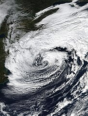
English: Taken from the VIIRS instrument on the Suomi-NPP satellite, this true color image of a Nor'easter was taken on October 27, 2021 at 17:43 (UTC) 1:43 PM (Local Time). When this image was taken the Nor'easter was coming off its peak earlier in the day at 09:00 (UTC) 5:00 AM (Local Time). Throughout the days of October 26 and October 27 this Nor'easter brought flooding and high-winds along the I-95 Corridor from about Washington DC up to Boston, this nor'easter would also become Tropical Storm Wanda in the Far North Atlantic on October 31. The estimated intensity of the Nor'easter at the time this image was taken was 65 MPH (55 KNOTS or 105 KMH) with a minimum central pressure of 980 Millibars (hPa). |
| Nĭk-gĭ | |
| Lài-nguòng | https://worldview.earthdata.nasa.gov/ |
| Cáuk-ciā | NASA/Suomi-NPP |
| 其他版本 |
|

| 拍攝地點 | | 位於此地的本圖片與其他圖片: OpenStreetMap |
|---|
版權說明
| 本作品由NASA創作,屬於公有領域。根據NASA的版權政策:“NASA的創作除非另有聲明否則不受版權保護。”(參見:Template:PD-USGov/zh,NASA版權政策或JPL圖像使用政策) | ||
 |
警告:
|
Ùng-giông lĭk-sṳ̄
Sōng-dĕk siŏh bĭk nĭk-gĭ/sì-găng lì káng hiā sèng-hâiu gì ùng-giông.
| Nĭk-gĭ/Sì-găng | Sáuk-liŏk-dù | Chióh-cháung | Ê̤ṳng-hô | Suók-mìng | |
|---|---|---|---|---|---|
| hiêng-káik-sì | 2021 nièng 11 nguŏk 7 hô̤ (LB) 20:34 | | 3,800 × 5,000(4.3 MB) | Hurricaneboy23 | Tweaks to levels |
| 2021 nièng 11 nguŏk 5 hô̤ (B5) 16:18 |  | 3,800 × 5,000(4.13 MB) | TheWxResearcher | Closer to a 3:4 Ratio | |
| 2021 nièng 11 nguŏk 5 hô̤ (B5) 15:46 |  | 4,000 × 5,000(2.93 MB) | TheWxResearcher | Uploaded a work by NASA/Suomi-NPP from https://worldview.earthdata.nasa.gov/ with UploadWizard |
Lièng-giék
Â-dā̤ gì hiĕk-miêng lièng gáu ciā ùng-giông:
Cuòng-mĭk ùng-giông sāi-ê̤ṳng cìng-huóng
Â-dā̤ gì gì-tă wiki găk lā̤ sāi cī-bĭh ùng-giông:
- en.wikipedia.org gì sāi-ê̤ṳng cìng-huóng
- fa.wikipedia.org gì sāi-ê̤ṳng cìng-huóng
- hak.wikipedia.org gì sāi-ê̤ṳng cìng-huóng
- pa.wikipedia.org gì sāi-ê̤ṳng cìng-huóng
- pt.wikipedia.org gì sāi-ê̤ṳng cìng-huóng
- shn.wikipedia.org gì sāi-ê̤ṳng cìng-huóng
- simple.wikipedia.org gì sāi-ê̤ṳng cìng-huóng
- vi.wikipedia.org gì sāi-ê̤ṳng cìng-huóng
- zh-min-nan.wikipedia.org gì sāi-ê̤ṳng cìng-huóng